Resolution through Technology
![]()
Resolution through Technology
![]()
| About | Projects | Pictures | Contact | Sitemap |
Here's some screenshots of some of our projects.
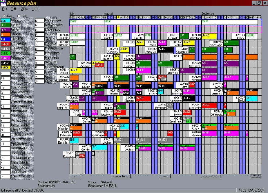 This program was designed to replace a wall-display, which represented up to 3-months of activity; showing which resources are allocated to each job. The 'manual' display needed constant updating, and was only visible to anyone directly in front of it. By accessing a database, the display could be scrolled back and forward to any date (and up/down for more rows), and the display automatically resizes to the screen size; big for the flat panel display, or smaller for anyone's PC, either locally or on other sites via the company's network.
The column at the left is a list of the primary and secondary resources, to act as a key (categories of resources may be hidden). Each column in the main area represents one day, with the weekends and 'today' highlighted in blue and yellow. The white boxes show the job details, to the left of the associated resources. Resources can be added to a job by dragging them from the 'key'. Options allow 'free' resources (unallocated), and also 'unavailable' (people on holiday, or equipment being serviced) to be shown in rows at the top of the main display.
At the bottom, there are buttons to scroll or zoom the display, or return to 'today'. When the mouse pointer is positioned over parts of the display, popups appear, showing more details.
After using the program for over 5 years, the customer has asked me to make some additions, like changing some colours to indicate status..
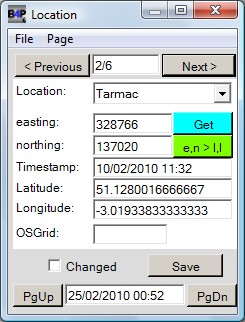 This is a screenshot of a program written to run on a mobile GPS device, to log the positions of streetlamps during an inspection for a local council. In order to fit the small screen, there are a number of pages, with drop-down controls for all the input values which could be anticipated (to minimise keyboard input). The blue 'Get' button changes colour to indicate the GPS status, and when clicked, fills in the current GPS coordinates into the appropriate boxes (and also converts to e,n (OSGB) coordinates. The green button converts e,n values (where available) to latitude and longitude.
The device's clock can also be set from the GPS time, or manually, if GPS is unavailable. (it often forgot the time when the batteries were changed).
In order to fit the limited memory, the program loads one selected area, or street, at a time.
Another program was written to run on a PC, to extract the results from the database on the device(s), to update a 'master list' (because the device was incompatible with the PC database). A future development of this will be to run the program on a tablet device, possibly running Android (or maybe an iPad, if possible). If the device has 3G or Wifi, then maybe the results can be uploaded while 'on-site'. It could also allow the current location to be overlaid onto a map.
Last modified on ... 2nd June 2014